|
by
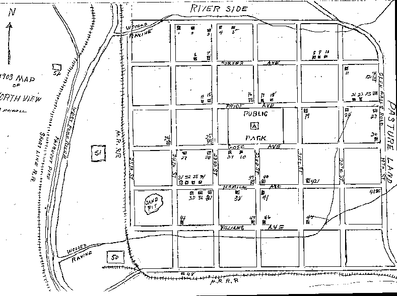
(This early history of North View was written by Paul E. Maxwell and generously given to my family by him. He is now deceased and I am taking the liberty of sharing Mr. Maxwell's history because I know he would want it shared. Mr. Maxwell's work is not dated but we believe it was written sometime during the 1920's.-OSH) The section of Clarksburg known as North View derives its name from a sub-division created by the Pine Grove Development Company near the turn of the century. When our family moved there in early March, 1903, North View was encompassed by the Glen Falls Road, now 19th street, beginning at the point where it leaves the West Fork River bluff extending north to what is now Gould Avenue, westward on Gould to the river, thence south and eastward along the river to the starting point. The area between the railroad and the river was a mixture of level and hilly, open field and woodland approximately one quarter mile wide at its central part and tapering to nothing at each end. At the widest point adjacent the railroad was the Lafayette Window Glass Plant and below it along the river edge, an abandoned brick yard. All the land north and east of the railroad was laid off in some thirty-six city blocks as they are today. At the highest point of the area, between Goff and Pride Avenues and bisected by 22nd Street was approximately one and one- half city blocks fenced off for a public park. It had been planted with small maple trees and a wind mill stood in the center pumping water to irrigate them. Clarksburg's city limits at that time ended at the railroad near the Hazel-Atlas Glass Plant. Between there and North View was a widely scattered settlement known as Reynolds Addition. Dirt roads in summer and mud roads in winter through this community was our only access to Clarksburg and the outside world. To the north was a large expanse of level land know as Riverside which gradually ascended into a large hill. Then, as it still does, a road leading to Glen Falls passed through the low gap in the hill. Behind the hill to the left of the road and extending to the river was the farm of Otis Stout. Later it was subdivided and is now called Arlington. To the right of the road likewise extending to the river was the Charles Green farm. And on the south side of the hill facing Clarksburg was another farm, which in later years became Barnes Addition. These farms with their orchards, chestnut groves, berry thickets, etc. and the wild land along the river formed a veritable wilderness paradise for a ten-year old. And with my favorite playmates I fished, hunted, swam and explored it endlessly. Things were changing rapidly. In less than a year after our arrival the Lafayette Glass Plant expanded from a pot furnace to a continuous tank operation, tripling the number of glass workers and their families. In 1905, the Peerless, later the Rolland Plant, was built, again doubling the glass working population, who were for the most part French or of French origin. A coal mine was opened on the Glen Falls Road and most of its workers, many of whom were Italian, chose North View as their abode. Scores of families were attracted from Braxton, Gilmer, and Ritchie counties to fill Clarksburg's growing demand for industrial manpower. Around 1914, a zinc smelting plant began operation along the river at the old brick yard site and nearly all its work force were immigrants directly from Spain. So North View very early became a cosmopolitan community and its residents today are predominately descendents of those early settlers. In 1912, a street car line was extended through the heart of the town to the glass plants. Board walks lined the streets in all directions making it possible for the first time to get about in wet weather without muddy shoes. A central business district arose around the intersection of Goff Avenue and 19th Street including a post office, oddly enough called Manayka, a drug store, a motion picture theatre, several groceries, two doctors and a dentist. (The dentist was Dr. Prather and the two doctors were Dr. Pendleton and Dr. Goff.-OSH) Other improvements in the immediate neighborhood were a modern school house and two churches. By this time North View, including all the territory to the Clarksburg city limits had been incorporated as a municipality with its own city hall, jail, fire and police departments. This was North View in the summer of 1917 when I left for the army during World War I, only to return as a resident for a few sporadic intervals over the next few years. It (North View) had come a long way since 1903, but was still a far cry from the thriving, citified section of Clarksburg that it is today. Excluding the few in Reynolds Addition and the surrounding country side, a complete list of our neighbors and their addresses at the time (1903) follows. They total some forty three families and a population of approximately 200 living in an area of 36 blocks not including the industrial sites along the river. (Note: Horner Avenue later became Gould Avenue-OSH) Ables, Riley 2000 block Horner Avenue Barraux, Goff Avenue/19th Street Bunnell, Nate Goff Avenue/23rd Street Carmilla, 2300 block Hamill Avenue Caussain (Caussin), Julien Hamill Avenue/22nd Street Corbin, Charles 2200 block Goff Avenue Coulson, John Williams Avenue/24th Street Cunningham, Newton I. Horner Avenue/23rd Street Duffy, Jackson 1900 block Pride Avenue Girard, Alfred Goff Avenue/23rd Street Greaver, William 2200 block ? Avenue Haught, P. A. 2200 block Goff Avenue Howard, John H. Hamill Avenue/21st Street Kidd, C. H. Goff Avenue/23rd Street Kidd, Jas. A. Pride Avenue/20th Street Kopp, Eugene Goff Avenue/24th Street Leuliette, Hyppolyte 2300 (2200?) block Hamill Avenue LaChappelle, Hamill Avenue/22nd Street Lee, 2100 block Pride Avenue Long, David Horner Avenue/20th Street Malfregeot, Jules 2300 block Goff Avenue Maxwell, W. A. Pride Avenue/22nd Street Moats, Schuyler ? Avenue/24th Street Moine, Lucy Hamill Avenue/23rd Street Moine, 2200 block Hamill Avenue Moine, Hamill Avenue/22nd Street Nichols, Frank 2300 block Goff Avenue O'Donnell, John 2000 block Horner Avenue Parrish, Floyd 2300 block Horner Avenue Reager, Charles ? Avenue/23rd Street Ritter, S. C. Pride Avenue/22nd Street Rolland, Charles Hamill Avenue/24th Street Ross, Charles 1900 block Pride Avenue Scory, Valentine Pride Avenue/21st Street Slaughter, Jake 2000 block Horner Avenue Swisher, Dan Williams Avenue/21st Street Trunick, Ben Williams Avenue/22nd Street Trunick, Ed 2300 block Hamill Avenue Trunick, Henry 2300 block Hamill Avenue Trunick, John Williams Avenue/22nd Street Winters, Nancy 2300 block ? Avenue Wolfe, Jake On river below Lafayette Plant Yeager, Charles
2300 block Rail Road Avenue
Early Map of North View
Key to Map
(Although Mr. Maxwell is no longer with us, I personally would like to extend my sincere thanks for the history he has shared with us and believe there are many others who will also appreciate his generosity. - Olga S. Hardman) |